Isaiah 40:6-8 (NASB)

Isaiah 40:6-8 (NASB)

6) A voice says, “Call out.”
Then he answered, “What shall I call out?”
All flesh is grass, and all its loveliness is like the flower of the field.

7) The grass withers, the flower fades,
When the breath of the LORD blows upon it;
Surely the people are grass.

8) The grass withers, the flower fades,
But the word of our God stands forever.

Showing posts with label Valley of Achor. Show all posts

Friday, November 24, 2017

Under the watch of a HOLY God (Part II.b)

Defeat is a hard experience. Israel as a whole faced defeat before Ai with Achan's disobedience. It was trying time indeed. But was God still sovereign? Why, you ask, would the God of Isreal allow His people to experience such pain?

Return the question to yourself. What child, although dearly loved and cared for by their parents, lives a life free from pain? Do not children exercise choice in their activities, even choices that may lead to pain? Well, are we kept devoid of choice before God? Surely not. Therefore, pain is something we face . . . ever since the choice Adam and Eve made. Nevertheless, God is sovereign during all times. Israel served a Holy God who gave them real choices with real consequences. Yet, as Israel saw at the 2nd Battle of Ai, this Holy God remained sovereign. The battle was not won by Israel's might or morale (they lost the first time). No, the battle was won by God's hand.

"God of the Hills and Valleys" by Tauren Wells


Facts, Traditions, and Widespread Beliefs regarding the Valley of Achor and Ai: (continued)

  • Geographical City of Ai:
    • Genesis 12:7-9, "So he [Abram] built an altar there to the LORD who had appeared to him. Then he proceeded from there to the mountain on the east of Bethel, and pitched his tent, with Bethel on the west and Ai on the east; and there he built an altar to the LORD and called upon the name of the LORD."
    • Joshua 7:2-5, "Now Joshua sent men from Jericho to Ai, which is near Beth-aven, east of Bethel, and said to them, 'Go up and spy out the land.' So the men went up and spied out Ai. They returned to Joshua and said to him, 'Do not let all the people go up; only about two or three thousand men need go up to Ai; do not make all the people toil up there, for they are few.' So about three thousand men from the people went up there, but they fled from the men of Ai. The men of Ai struck down about thirty-six of their men, and pursued them from the gate as far as Shebarim and struck them down on the descent, so the hearts of the people melted and became as water."
    • Ezra 2:1-29, "Now these are the people of the province who came up out of the captivity of the exiles whom Nebuchadnezzar the king of Babylon had carried away to Babylon, and returned to Jerusalem and Judah, each to his city . . . the sons of Kiriath-arim, Chephirah and Beeroth, 743; the sons of Ramah and Geba, 621; the men of Michmas, 122; the men of Bethel and Ai, 223 . . ."
      • Ai lay above Jericho in altitude (Joshua 7:2-5)
      • Ai lay close to Beth-aven and just east of Bethel (Gen. 12:7-9; Joshua 7:2-5)
      • A mountain lay between Bethel and Abram's Ai (Gen. 12:7-9)
      • Ai was walled with a city gate (Joshua 7:2-5)
      • Ai apparently lay west of a place called Shebarim (assuming the men of Israel fled back eastward to camp at Gilgal--see following passages), which was close to a descending slope (Joshua 7:2-5)
      • Ai was repopulated by Israelites sometime after Joshua's conquest and prior to Babylonian captivity (Ezra 2:1-29)
    • Joshua 8:10-29, "he [Joshua] went up with the elders of Israel before the people to Ai. Then all the people of war who were with him went up and drew near and arrived in front of the city, and camped on the north side of Ai. Now there was a valley between him and Ai. And he took about 5,000 men and set them in ambush between Bethel and Ai, on the west side of the city . . . and Joshua spent that night in the midst of the valley. It came about when the king of Ai saw it, that the men of the city hurried and rose up early and went out to meet Israel in battle, he and all his people at the appointed place before the desert plain. But he did not know that there was an ambush against him behind the city. Joshua and all Israel pretended to be beaten before them, and fled by the way of the wilderness . . . When Joshua and all Israel saw that the men in ambush had captured the city and that the smoke of the city ascended, they turned back and slew the men of Ai. The others came out from the city to encounter them, so that they were trapped in the midst of Israel, some on this side and some on that side; and they slew them until no one was left of those who survived or escaped . . . All who fell that day, both men and women, were 12,000—all the people of Ai . . . Israel took only the cattle and the spoil of that city as plunder for themselves, according to the word of the LORD which He had commanded Joshua. So Joshua burned Ai and made it a heap . . ."
      • A large valley lay on the north side of Ai.
      • The valley north of Ai led to a desert plain.
      • Concealing terrain lay on the west of Ai.
      • Cattle were taken alive from Ai.
      • The ruins of Ai were plundered.
      • Ai's city gate was on the north side.
      • Ai was burned.
      • Both men and women lived at Ai
    • Encyclopaedia Britannica - Modern archaeology associates ancient Ai with et-Tell. But those ruins appear to only be from before and after Israelite conquest. Thus many archaeologists assume that Ai was identified by the Israelites with Bethel, placing Bethel-Ai at Beitin 1.5 miles west of et-Tell. This does not cohere with Joshua identifying Ai to lie east of Bethel).
    • Dr. David Livingston - considers the Biblical account to be historical and favors Khirbet Nisya (Kh. Nisya) as site of ancient Ai:
      • Kh. Nisya was ~5 acres in size, compared to the 11 acre size of "greater" Gibeon (Joshua 10:2)
      • Kh. Nisya appears to be a reasonable topographical fit for Joshua's Ai.
      • Kh. Nisya also reveals evidence of Israelite resettlement just prior and immediately after the Babylonian Captivity, which Bryant Wood's Kh. el- Maqatir does not show thus far. Upcoming website on Kh. Nisya dig site: "Ai Archaeological Park"
      • However, Kh. Nisya shows no sign of walls and a gate at time of Joshua
      • Dr. Livingston originally placed Beth-aven at Beitin, but now places Beth-aven at Kh. el-Maqatir. This would still hardly make Ai (if Ai was at Kh. Nisya) close to Beth-aven compared to Bethel (at el-Bireh), as mapped below. So, placement of Beth-aven at Kh. el-Maqatir and Ai at Kh. Nisya does not seem to fit the description in Joshua 7:2
      • Also, Dr. Livingston does not mention evidence of Kh. Nisya having been burned.
      • Region of et-Tell, Kh. Nisya, and Kh. el-Maqatir (Biblicalarcheology.org).
        Land elevation can be checked by clicking on terrain on elevationmap.net maps.
    • Dr. Bryant Wood - places Ai at Khirbet el-Maqatir. The Bryant Wood team has found:
      • Remains of a gate facing north at this site
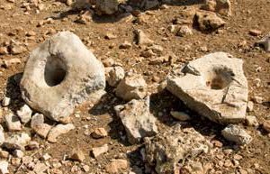
Socket Stones
Gate Socket Stones at Kh. el-Maqatir (Answers in Genesis)
Infant burial jar found at Kh. el-Maqatir (Biblearchaeology.org)
      • Infant burial jar found at Kh. el-Maqatir affirms that both men and women were living there.
      • Kh. el-Maqatir remained a desolate ruin after destruction by fire in the time of Joshua.
      • This site fits the Joshua account well. The mountain between Ai and Bethel noted in Genesis may be explained by an earlier Ai ("Getting Archaeology Right at Ai", Footnote 2) being located at et-Tell. This would leave the sites of either Baytin/Beitin or Kh. el-Maqatir as the mountain Abram stood on with Ai on the east and Bethel on the west.


Saturday, September 2, 2017

Under the watch of a HOLY God (Part II)

Now what is the non-textual evidence for the Valley of Achor and Israelite conquest of Ai?

This post was sadly delayed due to Blogger crashing and subsequent need to do a bit of re-writing and re-researching. But with that extra work I do now have extra information on the Valley of Achor. This requires splitting up the original post into at least two parts. Examination of evidence for Ai will be in the second part. I'd better post what I have about Achor forthwith to avoid another crash.


Facts, Traditions, and Widespread Beliefs regarding the Valley of Achor and Ai:

  • Geographical Valley of Achor:
    • Joshua 7:24-26, "Then Joshua and all Israel with him, took Achan the son of Zerah, the silver, the mantle, the bar of gold, his sons, his daughters, his oxen, his donkeys, his sheep, his tent and all that belonged to him; and they brought them up to the valley of Achor. Joshua said, “Why have you troubled us? The LORD will trouble you this day.” And all Israel stoned them with stones; and they burned them with fire after they had stoned them with stones. They raised over him a great heap of stones that stands to this day, and the LORD turned from the fierceness of His anger. Therefore the name of that place has been called the valley of Achor to this day."
      • The valley of Achor lay in hill country
      • One should look for reference or sign of a stone heap (not yet discovered to my knowledge)
      • The modern name of the valley should relate to the original name of Achor
      • Achor - Hebrew for "disturbance" or "trouble"
      • Jerusalem.com - The Prat River running along the Wadi Kelt is considered the River Perath named in Jeremiah 13:3-5. Among the springs supplying the River Perath, the Spring of Ein Kelt is associated with the River Kerith belonging to the Kerith Ravine named in 1 Kings 17:3.
        • Strong's Concordance - "Perath" in Jeremiah 13:3-5 is also translated as the "Euphrates". The word derives from a root meaning "to break forth" or "rushing"
        • Strong's Concordance - "Kerith" in I Kings 17:3 derives from "karath" which means "to cut off" or "cut down".
    • Joshua 15:1, 5-8, "Now the lot for the tribe of the sons of Judah according to their families . . . And the border of the north side was from the bay of the sea at the mouth of the Jordan. Then the border went up to Beth-hoglah, and continued on the north of Beth-arabah, and the border went up to the stone of Bohan the son of Reuben. The border went up to Debir from the valley of Achor, and turned northward toward Gilgal which is opposite the ascent of Adummim, which is on the south of the valley; and the border continued to the waters of En-shemesh and it ended at En-rogel. Then the border went up the valley of Ben-hinnom to the slope of the Jebusite on the south (that is, Jerusalem) . . ."
Modern walk from Ein Hajla Spring to Gey Ben Hinom St, Jerusalem. This is the region of Joshua's Judah-Benjamin border, on which the Valley of Achor lay, just south or southwest of Jericho.
      • Travel Palestine - The name of Beth Hoglah in Joshua 15 is retained by the modern day Ain Hajla Spring.
      • Wikipedia - The modern West Bank settlement of Beit HaAravah is named after the town of Beth Aravah named in Joshua 15, whose general location it shares on the Aravah/Arabah plain. In the 1930s-1940s, Jewish settlers began cultivating the soil of Beit HaAravah (after washing out the salt), making it known for its produce of vegetables and fruit throughout the country (see Hosea 2 verses below).
      • Joshua 15 implies that the stone of Bohan lay in the Valley of Achor. Therefore the Valley of Achor lay "above" (likely in altitude) and North-west of Beth-arabah, since the northern boundary of Judah was being described from east to west in Joshua 15. North-west of modern day Beit HaAravah lie Aqabat Jabr and the east entrance to the Wadi Kelt valley.
    • Joshua 18:11-20, "Now the lot of the tribe of the sons of Benjamin came up according to their families, and the territory of their lot lay between the sons of Judah and the sons of Joseph. Their border on the north side was from the Jordan, then the border went up to the side of Jericho on the north, and went up through the hill country westward, and it ended at the wilderness of Beth-aven. From there the border continued to Luz, to the side of Luz (that is, Bethel) southward . . . The border extended from there and turned round on the west side southward . . . Then the south side was from the edge of Kiriath-jearim, and the border went westward and went to the fountain of the waters of Nephtoah. The border went down to the edge of the hill which is in the valley of Ben-hinnom, which is in the valley of Rephaim northward; and it went down to the valley of Hinnom, to the slope of the Jebusite southward, and went down to En-rogel. It extended northward and went to En-shemesh and went to Geliloth, which is opposite the ascent of Adummim, and it went down to the stone of Bohan the son of Reuben. It continued to the side in front of the Arabah northward and went down to the Arabah. The border continued to the side of Beth-hoglah northward; and the border ended at the north bay of the Salt Sea, at the south end of the Jordan. This was the south border. Moreover, the Jordan was its border on the east side."
      • It is clear that Judah's northern border shared much of Benjamin's southern border.
      • Therefore, the Valley of Achor (Joshua 15) lay on the southern side of Benjamin.
      • Jericho lay on the northern border of Benjamin.
      • Therefore, the Valley of Achor lay south (or south-west) of Jericho.
      • Shalom Israel Tours - The Jewish Mitzpe Jericho ("Jericho Lookout") community of 450 families has a clear view of Jericho from the southeast mountains. This community is adjacent to the Wadi Kelt/Nachal Prat nature reserve.
View from Mitzpe Jericho of the Jericho plain (Shalom Israel Tours)

    • Isaiah 65:9-10, "'I will bring forth offspring from Jacob,
                  And an heir of My mountains from Judah;
                  Even My chosen ones shall inherit it,
                  And My servants will dwell there.
            'Sharon will be a pasture land for flocks,
                  And the valley of Achor a resting place for herds,
                  For My people who seek Me.'"

    • Hosea 2:14-15, "'Therefore, behold, I will allure her,
                  Bring her into the wilderness
                  And speak kindly to her.
            'Then I will give her her vineyards from there,
                  And the valley of Achor as a door of hope.
                  And she will sing there as in the days of her youth,
                  As in the day when she came up from the land of Egypt.'"
      • The Shalom Israel Tours link above already mentioned Israelite settlement in the vicinity of Wadi Kelt (as suggested by Isaiah's "for My people")
      • Look for a roadway in the Vally of Achor (Hosea's "door of hope")
Tomb ibn Taymiyya
Shepherd in the vicinity of the Wadi Kelt (Israel Tour Guide)
      • Israel Tour Guide - The Wadi ("valley") Qelt/Kelt and Nahal ("stream bed") Prat run east from Jerusalem to Jericho, where the Nahal Prat runs into the Jordan River. The Nahal Prat is supplied by three springs. Shepherds with their sheep can be seen along the Wadi Kelt/Qelt. Hasmonean period aqueducts enabled cultivation of figs, dates, pomegranates, and citrus up through the early Arab period. Palaces, settlements, monasteries, and an Israelite Iron Age ruin dating to the time of the Israelite kings are also found in the valley.
      • Shalom Israel Tours - In the En Prat nature reserve is the Firan Monastery, which is surrounded by cultivated terraces, orchards, and cisterns.
      • See the Holy Land - The Wadi Qelt's 35 km winding course provided the route for a large section of a Roman roadway running from Jerusalem to Jericho. St. George's Monastery built in the 5th century into the cliff face of the Wadi Qelt is known for hospitality.
Monastery of St George
Monastery of St. George built into the cliff face of the Wadi Kelt (See the Holy Land)
 
 . . . Part B to follow.